Bølgeformede skyer, tordenbyger
17 maj 1998 18:18 UTC
Syd for Frankrig. Nederst til højre ligger Middelhavet. Et lavtryk over Spanien genererer en kraftig syd-sydøstlig over Cevennes (1), og skaber bølgeformede skyer. De ses både på det synlige og det infrarøde billede, i form af to let afvigende striber (2). Til venstre i billederne er der tordenstormskyer: cumulonimbus (3). Meget hvide pletter på det infrarøde billede, da deres meget høje toppe er meget kolde. Disse vertikale skyer har en markant skygge (4) der kan ses på det synlige billede om aftenen.
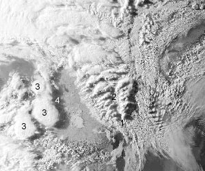
Synligt billede
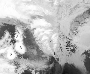
Infrarødt billede